


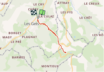
SityTrail - Le Ranfolly

HG74250
User

Length
9.3 km

Max alt
1807 m

Uphill gradient
638 m
Km-Effort
17.8 km

Min alt
1171 m

Downhill gradient
638 m
Boucle
Yes
Creation date :
2020-01-04 18:01:13.568
Updated on :
2020-01-04 18:03:21.198
--
Difficulty : Easy

FREE GPS app for hiking
 SityTrail
IGN / Geographical institutes
SityTrail Plus
The world is yours!
About
Trail Touring skiing of 9.3 km to be discovered at Auvergne-Rhône-Alpes, Upper Savoy, Les Gets. This trail is proposed by HG74250.
Positioning
Country:
France
Region :
Auvergne-Rhône-Alpes
Department/Province :
Upper Savoy
Municipality :
Les Gets
Location:
Unknown
Start:(Dec)
Start:(UTM)
320200 ; 5114330 (32T) N.
Comments